
Deusdedit Ruhangariyo
Special to ICT
Around the world: Study confirms Indigenous lands crucial for climate change mitigation in Brazil, $650,000 will go toward improving marine park health in Australia, and Ottawa unveils residential school map aiding search for missing children in Canada
BRAZIL: Indigenous lands and climate change
Brazil President Luiz Inácio Lula da Silva recognized an additional two Indigenous territories, including one 32,000-hectare (more than 79,000-acre) territory belonging to the Karajá peoples in Mato Grosso. According to a new study published in the journal Perspectives in Ecology and Conservation, this act alone could quite possibly be the best investment not just for Indigenous rights, but for securing the future climate stability of the state, Mongabay reported on June 25.
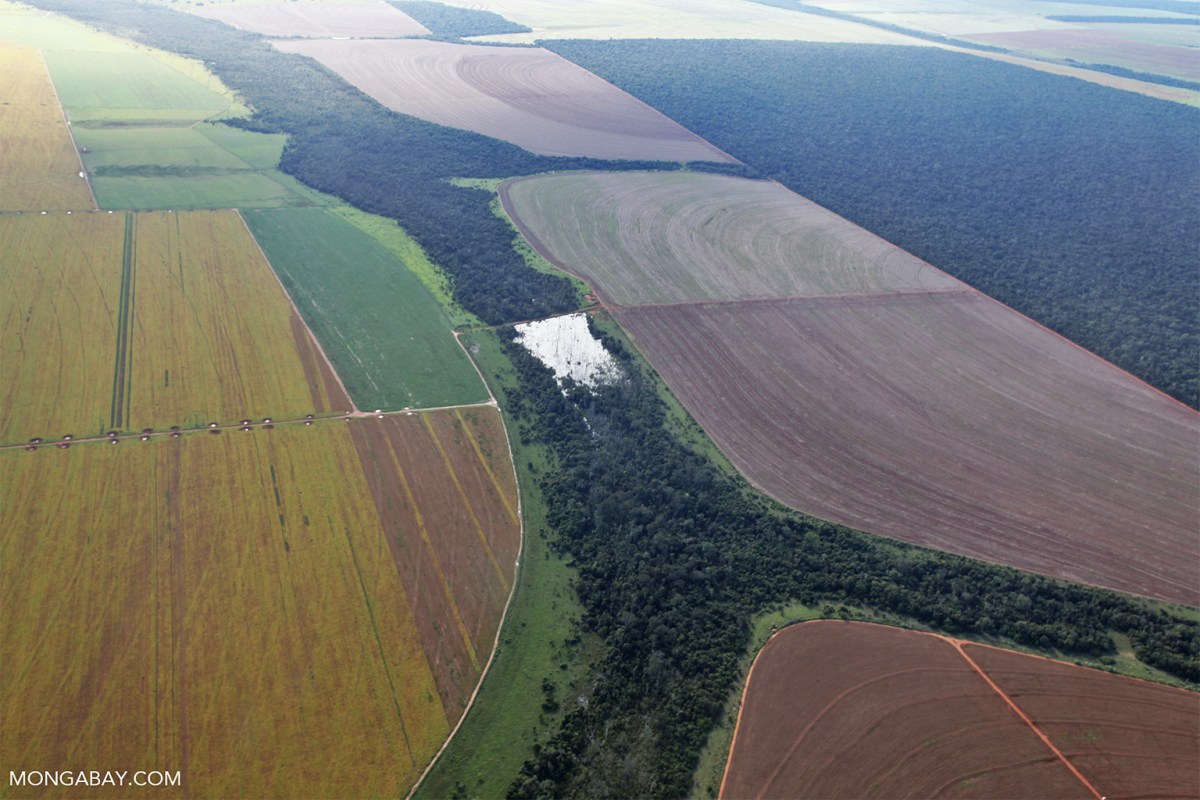
The state of Mato Grosso straddles two of Brazil’s largest biomes: The Amazon covers around two-thirds of the state, and the Cerrado covers the other third. Most of the remaining forest is protected within conservation units and Indigenous lands, which have stood as barriers to deforestation, forest fires, and degradation. But Mato Grosso is also Brazil’s leading producer of soybeans and meat, both of which have grown at the expense of the region’s native Cerrado and Amazon vegetation.
According to this study on Indigenous lands and conservation units in Mato Grosso, these protected areas are crucial for slowing down and regulating climate change impacts. However, the same study shows this barrier is weakening. The ability of protected areas to keep the forest intact has already begun to decline, especially on the southern edge of the Amazon, where forest degradation has been associated with intense droughts and forest fires.
“Mato Grosso is experiencing intense changes due to the expansion of pasture and agriculture,” Hellen Almada, a researcher at the Vale Institute of Technology in Brazil and the lead author of the study, told Mongabay. “Assessing whether external pressures compromise the capacity of protected areas to maintain their ecosystem services is crucial.”
The paper uses various datasets to analyze how human and natural disturbances affect the ability of Indigenous lands, conservation units, and private, multiuse areas to regulate things such as regional temperature and atmospheric water cycling. By assessing the differences in evapotranspiration, surface temperature, and surface albedo over a 20-year period, they were able to show that conservation units and Indigenous lands contribute more to climate regulation than multiple-use areas or lands outside of Indigenous lands and conservation units.
In recent decades, the increase in pasture lands and crops, much of it for meat or animal feed production, has transformed the landscape in Mato Grosso. The authors analyzed geospatial data, showing that native vegetation in Mato Grosso has decreased by 10 percent in the last two decades, from 73 percent in 2000 to 63 percent in 2020. Most of it has been converted to pasture and crops, such as soy. Of this, 69 percent is located in the Amazon and 31 percent in the Cerrado. The increased fragmentation of forests and rising global temperatures mean that forests are much more susceptible to both drought and fires. For example, the authors found that intense droughts increased the burned area in conservation units and Indigenous lands in both the Amazon and Cerrado.
Still, the study found that protected areas had three times fewer fires per square kilometer (per 0.38 square mile) than other areas in the Amazon, and they help to maintain low temperatures, low albedo (the fraction of light reflected from the Earth), and high evapotranspiration (the combined process of evaporation and transpiration), even during extreme droughts. This means that protected areas are not only essential for preserving forests and native vegetation, but it also means that as temperatures continue to increase, protected areas will be even more crucial for regulating the regional effects of climate change.
“The biggest takeaway for me is how intertwined global and local factors are in shaping ecosystem change,” Almada said, according to Mongabay.
For example, the greater susceptibility to fire of protected areas can be attributed to warming temperatures and frequency of droughts. The fires themselves can alter the energy balance of protected areas, intensifying local and regional impacts of native vegetation loss and leading to permanently degraded states.
“This highlights the critical importance of integrated approaches to conservation and land use that address both climate change and local human activities,” she said.
AUSTRALIA: Funds to improve marine parks
In a major advancement for marine conservation, $650,000 has been allocated to two projects aimed at enabling Traditional Owner groups to enhance their monitoring and management of Australia’s marine park health, National Indigenous Times reported on June 27.
The University of Western Australia and First Nations partners have secured funding to assist Traditional Owners in sharing Sea Country knowledge and supporting their efforts in marine park oversight.
One initiative involves the University of Western Australia collaborating with six saltwater Bibbulmun Noongar groups in Western Australia’s Southwest to expand and disseminate knowledge of culturally significant marine life and identify management priorities for Sea Country.
Another initiative enables the university to team up with the Mayala Inninalang Aboriginal Corporation to bolster the monitoring and protection of crucial reef species, such as trochus (a type of medium-to-large-sized, top-shaped sea snail).
The funding announcement took place at the University of Western Australia Oceans Institute with the presence of Patrick Gorman MP and Senator Sue Lines, alongside project leads Dr. Matt Navarro from the University of Western Australia School of Biological Sciences, and Dr. Tim Langlois from the Oceans Institute, as well as Traditional Owner project partners.
Navarro emphasized the importance of the funding in enhancing First Nations involvement in setting management priorities for marine parks.
“The Waatu Wardan Kaartdijin project symbolizes a significant collaboration across saltwater Bibbulmun Noongar peoples to ensure Traditional Owner culture is integrated into the management of Australian Marine Parks,” Navarro said, according to National Indigenous Times.
“The funding is vital for sharing Sea Country knowledge and fostering First Nations leadership in managing and establishing priorities for these marine parks.”
The Mayala Inninalang project, led by Drs. Jane Prince, Renae Hovey, and Matilda Murley, aims to create a monitoring program for Traditional Owners to manage their offshore marine resources, particularly culturally important intertidal invertebrate species.
Murley noted that an additional outcome would be the benchmarking of marine biodiversity in the Kimberley Marine Park.
“The project will enable the Mayala people to visit and connect with remote parts of their Sea Country, allowing them to effectively manage these pristine marine ecosystems,” Murley said.
This announcement is part of the broader Australian Government’s “Our Marine Parks” Round 4 program, which allocated over $2 million for eight projects across Western Australia to enhance marine park understanding and management through partnerships with Traditional Owners and other stakeholders.
The Australian Government has established 60 Australian Marine Parks nationwide, covering 43 percent of Australian waters, managed by Parks Australia.
CANADA: Map to aid search for residential school remains
The Canadian government has introduced a new interactive online map identifying the locations of residential schools. Experts believe it will assist in uncovering unmarked or forgotten graves of children who were compelled to attend these institutions, CBC News reported on June 29.
Many residential school buildings have been demolished, paved over, or repurposed since the first one opened in Canada in the 1830s and the last one closed in the mid-1990s.
The Indian Residential Schools Interactive Map will assist searchers in finding accurate locations of former buildings.
“It’s a very valuable resource,” said Andrew Martindale, an anthropology professor at the University of British Columbia, according to CBC News. “If we find evidence of a cemetery or a burial, and we know where it is relative to buildings in the 1930s, we can use this kind of information to say: ‘Where is this today?’”
Martindale mentioned the difficulty in obtaining information from jurisdictions about the history of former residential school land, including its changes and the names of the landowners.
“If we’re off by even a metre, it can have consequences in the work that we do,” said Martindale, a member of the National Advisory Committee on Residential Schools Missing Children and Unmarked Graves.
The free mapping tool features contemporary and historical aerial photos, allowing users to visualize where the institutions operated and what they looked like.
More than 100 Indigenous communities are engaged in residential school grave searches, and they had to pay for access to aerial maps from libraries and obtain records through access-to-information requests with government institutions, said Kimberly Murray, independent special interlocutor for missing children in unmarked burials.
While the tool may arrive too late to aid ongoing community searches, Murray said every new piece of data helps in the search for lost children.
“The more information that is out there for communities, the better,” said Murray, according to CBC News. “But I do think that Canada hasn’t gone far enough in what it’s made available.”
Approximately 150,000 First Nations, Inuit, and Métis were taken from their families during the time residential schools operated. Ottawa had used the Indian Act to force children to attend the government-funded institutions to be indoctrinated into Euro-Christian Canadian society.
My last thoughts
My final thoughts are in Brazil where a recent study confirmed Indigenous lands are crucial for climate change mitigation. This deserves high praise. It highlights the indispensable role of Indigenous stewardship in preserving our planet’s health.
Indigenous communities have long been the caretakers of their lands, maintaining ecosystems and biodiversity through sustainable practices passed down through generations. This study reinforces the necessity of acknowledging and respecting their profound connection to the environment.
We must urgently implement the findings of this study and take decisive action to return Indigenous lands to their rightful stewards. By doing so, we not only honor their cultural heritage and rights but also leverage their unparalleled knowledge and practices in our global fight against climate change.
Additionally, supporting Indigenous land rights can lead to more equitable and just societies, addressing historical injustices and empowering communities that have been marginalized for far too long.
Let us commit to supporting Indigenous peoples in reclaiming their lands and empowering them to lead the way in environmental conservation. The future of our planet depends on it.